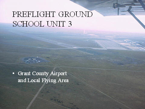
Preflight Ground School Unit 3
PREFLIGHT GROUND SCHOOL UNIT 3
Grant County Airport and Local Flying Area
This is One Big Airport!
Runway lengths
14L/32R 13503X300
04/22 10000X100
09/27 4500X90
18/36 3307X75
Numbering System
Set up referenced to magnetic north
Drop the zero
e.g. a runway with a heading 223 would be rounded to 220 and drop the 0 for a runway number 22
Numbering system
If you are on the runway ready to takeoff which way are you heading?
Crossing Runways
Crossing Traffic
Wake Turbulence
Landing but unable to hold short
Lighting and signage
Lighting and signage
Taxi lines are solid yellow
Hold short lines yellow lines 2 solid, 2 dashed
Black background yellow letter is the taxiway your on
Yellow background Black letter directs to taxiway
Red background White numbers indicates runway, co-located with hold short lines
Taxi lines
Hold short lines
Black background with a yellow letter designates the taxiway you are on
Yellow background with a Black letter directs to taxiway
Red background White numbers indicate the runway before you, usually co-located with a hold short line.
Other Markings
Class D airspace
Associated with an operational control tower
Grant County is Class D Airspace
Requires radio contact with tower prior to entering
They have to say your call sign back to you
You must maintain radio contact with the tower whenever flying inside class D
Frequencies
Atis 119.05
Ground 121.9
West Tower 128.00
East Tower 118.25
Approach Departure 126.4 and 134.35
School Frequency 123.5
When making a radio call remember:
Who you are calling
Who you are
Where you are
What your request is
“Grant Co ground BB 5, T hangers, taxi for takeoff west, tango”
Reply: BB5, Grant Co ground, taxi to runway 36, hold short runway 4″
ATC Radio Procedures
Page 12 paragraph 2.4 Big Bend Bible
Always repeat back instructions
Must repeat back hold short instructions
Crossing Runways
Never cross a runway unless cleared to do so
A clearance to taxi to a runway is a clearance to taxi on all taxiways and runways but not onto that runway
“BB 5 Taxi to 36”
You are cleared to taxi across 4 to get to 36 but not onto 36
Hold short clearances
“BB 5, Grant County Ground, taxi to runway 36, hold short runway 4”
This clearance allows you to taxi across all runways and taxi ways to get to 36 except they want you to hold short of runway 4.
Hold Short Clearances
Always repeat back the hold short
Stop at the hold line
Taxiing into position and hold clearances
You may taxi onto the runway in the threshold area and stop
Wait for takeoff clearance
Maintain situational awareness
Taxiing into position and hold clearances
“BB5, Grant Co tower, taxi into position and hold runway 36”
This clearance allows you to taxi onto the active runway and stop but is NOT a clearance to takeoff
Other Taxi Possibilities
“Grant County Ground, Big Bend 5, T hangers, taxi for takeoff East, Lima”
“Big Bend 5, taxi to runway 4”
Remember this clearance allows you to taxi to runway 4 but not onto the runway.
Other Taxi Possibilities
“Grant County Ground, Big Bend 5, T hangers, taxi for takeoff East”
“Big Bend 5, taxi runway 22 via Juliet 2”
East Departure (Continued)
“Grant County Tower, Big Bend 5 holding 22 Juliet 2, ready for takeoff”
“Big Bend 5 cleared for takeoff make a left crosswind departure”
East Departure (Continued)
“Grant County Tower, Big Bend 5 holding 22 Juliet 2, ready for takeoff”
“Big Bend 5 cleared for takeoff make a left downwind departure”
TPA 800 feet
Airport elevation is 1185
Pattern is 2000 msl
Subtract 1185 from 2000msl and you get the roughly 800agl
Normal Traffic pattern entry and all legs
Upwind
Crosswind
Downwind
Base
Final
Always enter at a 45º angle to the downwind leg
Right and left patterns (Left pattern 22 shown)
Lowest ceiling and visibility to get into MWH
You need 1000′ ceiling and 3 miles visibility
Practice Areas
Page 13 in the BB Bible
Description as printed on handout
6000 MSL and below keeps you out of IFR traffic’s way
Call in points
Blue Silos
Rock Ford Creek
Black Rock Lake
Industrial Area
Radio setup in the practice area
Top radio (#1)Tower or approach
Bottom radio (#2) School Frequency
Stalls
3000 MSL and above
This gives you the minimum 1500 AGL for recovery
Eastbound Departures
Must level at 2000 MSL until East low canal
For wake turbulence avoidance
Jets fly downwind at 3000 MSL
Magnetic and True North
True North
Located at the poles
Magnetic North
Located 700 miles South
This causes variation
Isogonic Lines
Isogonic Lines connect lines of equal variation
Agonic Line where variation is zero
Time
Lines of Longitude (meridians) pole to pole
Lines of Latitude (parallels) parallel to themselves
Prime Meridian or first line of longitude runs through Greenwich England
There are 360 meridians divided by 24 hours equals 15 degrees per hour
MWH is 8 hours from Greenwich 7 this time of year
To Convert to Zulu
1. Convert to military time
2. Add the conversion factor
Daylight ends (the last Saturday in October) 10/28
Daylight Savings (the first Saturday in April) begins 4/5
Wake Turbulence
Theory
How are they generated (pressure differential)
Peak Tangential speed at 300 fps
Heavy clean slow
Vortex Formation
Wake Turbulence
Vortex Behavior and Avoidance
Levels off 800 to 1000 feet below
Sink at a rate of several hundred feet minute
No wind vortex moves outward at 2 to 3 kts
A light crosswind 1 to 5 kts causes upwind vortex to stay on the runway
Turbulence and higher wind can cause early break up
Wake Turbulence
Intersection departures
Watch the nose wheel
Same runway
Watch the nose wheel
Cruise avoidance
Security Precautions
You must have a solo endorsement to have the key to the airplane.
You must also carry picture ID


